In 1968 Congress passed the National Trail System Act, which established 19 national scenic and historic trails throughout the United States. A "scenic" trail offers maximum outdoor recreation potential, while a "historic" trail has national or historical significance, like an original trade, exploration, migratory or military route.
Thousands of miles of trails have been created as the Act has been amended over the years. Today, some of the best known gems of the National Trail System are the 2,000 mile Appalachian Trail in the east and the 2,300 mile long Pacific Crest Trail in the west. From the Cherokee Trail of Tears used by the Cherokee Nation during its removal from ancestral lands in the east in 1838, to The Iditarod Trail in Alaska that provided a route for the nineteenth century Klondike Gold Rush, this Act preserves trails for establishment, protection and study. The Act provides the possibility of establishing trails not only within the United States, but also within its territories and beyond national boundaries. The Juan Bautista de Anza Trail begins in Sonora, Mexico and extends to San Francisco and is managed in cooperation with the US and Mexican governments.
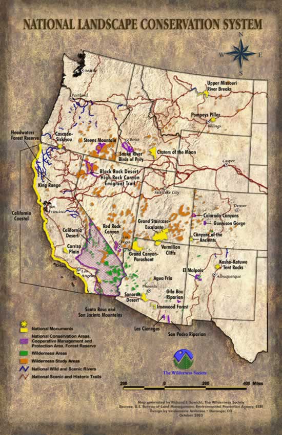
BLM's National Landscape Conservation System manages portions of nine National Historic Trails (about 3,623 miles) and two National Scenic Trails (about 641 miles). These trails offer hikers and others great opportunities to explore scenic, historic, natural, and cultural resources. Several segments traverse some of the National Monuments and Conservation Areas that are part of the NLCS.
National Historic Trails that Traverse the NLCS
The California Trail
This trail facilitated the largest migration in American history. More than 200,000 gold-seekers and farmers followed this route to the gold fields and farmlands of California during the 1840’s and 1850’s. Today more than 1,000 miles of trail still exist in the undeveloped lands between Casper, Wyoming and the West Coast. The main route begins at a variety of points along the Missouri River, and leads to various points in California, Oregon, and Sierra Nevada. About 2,171 miles of this system cross public lands, where most of the physical evidence of the migration is located. Eventually more than 240 historic sites along the trail will be opening for public use. Congress established this National Historic trail in 1992.
El Camino Real de Tierra Adentro
El Camino Real was the primary route between the colonial Spanish capital of Mexico City and the Spanish provincial capitals at San Juan de Los Caballeros, San Gabriel, and Santa Fe. This trail provides a window into the route of trade and cultural exchanges among Spaniards and other Europeans, American Indians, Mexicans, and Americans. These cultural exchanges helped shape the culture of the settlements in the American Southwest. Before 1821 Mexico did not officially allow trade with the United States, and thus trail was often very risky for those attempting to smuggle goods. After 1821 El Camino Real became a legitimate means for American goods to enter Mexican villages. This trail was added to the National Historic Trail System in 2000.
Mormon Pioneer Trail
From 1846 to 1869, more than 70,000 Mormons traveled west along what is now known as the Mormon Pioneer Trail. The famous Mormon Bingham Young led the Mormons on this trek of hundreds of miles through extremely harsh and inhospitable conditions. This trail crosses five states, beginning in Nauvoo, Illinois, traveling across Iowa, connecting with the Great Platte River Road at the Missouri River, and ending near the Great Salt Lake in Utah. Much of the trail is no longer visible, with the exception of a few long stretches in Wyoming. Congress established the 1,300 mile long Mormon Pioneer National Historic Trail as part of the National Trails System in November 1978.
Nez Perce Trail
Chased by the US Army in 1877, three Chiefs led 750 Nez Perce men, women, and children across 1,170 miles through western mountains. Their trip lasted from June to October, and this desperate and circuitous route to escape the pursuing forces is now called the Nez Perce Trail. The Trail stretches from Wallowa Lake, Oregon, to the Bear Paw Battlefield near Chinook, Montana. The trail actually bisects Yellowstone National Park and then heads north to Montana. The Nez Perce were attempting to seek refuge in Canada, but most were overtaken near the Bearpaw Mountains, just shy of the border. This trail was added by Congress as a National Historic Trail in 1986.
Oregon Trail
For eight decades during the 1800s, the Oregon Trail served as main mechanism for people to move into the western part of the United States. The Trail ran approximately 2,000 miles west from Missouri towards the Rocky Mountains. The Mormon Trail paralleled much of the Oregon Trail, connecting Council Bluffs to Salt Lake City. This was not an original trail; in fact it began as an unconnected series of trails used by Native Americans mostly for trade. Large-scale migration began in 1843, when a wagon train of over 800 people with 120 wagons and 5,000 cattle made the arduous five-month journey. Though much of the trail has disappeared due to the construction of towns and highways, over 300 miles of ruts still exist as well as 125 preserved historic sites. Congress designated this trail as an official National Historic Trail in 1978.
Iditarod Trail
Used by native hunters, then by Russian explores, and then by 20th century gold seekers, the Iditarod trail in Alaska is not a single trail, but rather a network of 2,300 miles of trails. The trail begins in a town called Steward, 50 miles north of what eventually became the Alaska Railroad, and ends 1,150 miles later in the town of Nome. In 1925, a diphtheria epidemic threatened to wipe out the population of Nome. The desperately needed serum was raced from Nenana to Nome by sled dog teams along this trail. The 20 mushers covered almost 700 miles in little more than 127 hours (about six days) in temperatures that rarely rose above 40 degrees below zero and winds sometimes strong enough to blow over dogs and sleds. The serum arrived in time to prevent the epidemic, saving hundreds of lives. Each year this remarkable feat is commemorated with a Sled Dog Race from Anchorage to Nome. Congress designated this trail as a historic trail in 1978.
Pony Express
This famous trail was used by men on horseback to send mail from Missouri to California in an unprecedented ten days. This relay system became the nations’ most practical means of sending information from the east to the newly settled west. The trail was only in operation for 18 months, between April 1860 and October 1861, but it proved the feasibility and necessity for this type of communication route. Time and human activities have decimated most of the original trail. Yet, it includes 120 historic sites and 50 Pony Express stations or station ruins. This trail was designated in 1992 and is managed in part by the National Park Service and the Bureau of Land Management.
Lewis and Clark Trail
In 1804 Merriwether Lewis and William Clark departed from Camp Wood in what is today Illinois on a voyage of discovery. President Jefferson requested that Congress fund an expedition to the unexplored west shortly before the Louisiana Purchase. Lewis and Clark were ordered to write accounts of all they did and saw, including the plants and animals encountered and the types of people they met. They also were asked to map out as much of the land as possible. Lewis and Clark along with 45 other men traveled for three years through lands that would later become 11 separate states. Most of the trail they took follows the Missouri and Columbia rivers. This trail is the second longest of the National Historic and Scenic trails and totals 3,700 miles. Much of the trail still remains intact today and it is possible to follow some of it by automobile or by hiking and biking. Segments run through the Upper Missouri River Breaks National Monument. Congress established the Lewis and Clark trail in 1978.
San Juan Bautista de Anza Trail
This trail commemorates the route taken by the Spanish commander Juan Bautista de Anza when he led a group of 30 soldiers and their families to found a presidio (fortress) near San Francisco Bay. Juan Bautisa de Anza led the group from Sonora Mexico all the way to San Francisco in an attempt to help Spain gain control of Pacific coast against British and Russian incursions. The 240 individuals on this expedition set out on October 23, 1775 and arrived at Monterey on March 10th 1776. The cultures and traditions of the families Anza escorted had a large impact on the shaping of the unique culture of the southwest and California. The trail is about 1,200 miles long and was established by Congress as a National Historic trail in 1990.
National Scenic Trails that Traverse the NLCS
Continental Divide Trail
When completed, this trail will climb up and down the Rocky Mountains from Canada to Mexico. The trail will go through five states, 25 National Forests, 20 Wilderness areas, three National Parks and one National Monument. Congress recognized the unique scenic quality and cultural characteristics of this environment and in 1978 identified a 100-mile-wide corridor straddling the Continental Divide for the future placement of the Continental Divide Trail. It is estimate that currently only about 70 percent of the trail is usable, mostly due to a lack of funding, budget cuts, and low public awareness. There are new connections within the trail that need to be developed and many existing areas that need to be repaired in order to meet National Scenic Trail standards. When completed the trail should serve hundreds of thousands of people a year, and provide resources for activities such as hiking, horseback riding, biking, and cross-country skiing.
Pacific Crest Trail
This magnificent trail zigzags from Mexico to Canada cutting through California, Oregon, and Washington State. This trail boasts the greatest elevation changes of all the National Scenic Trails. The trail traverse extremely diverse ecosystems, from the deserts of southern California to the rainforests of the Pacific Northwest. Thousands of hikers enjoy this trail each year, some for only a few miles or days, others hiking the entire length of the trail in one season. The trail is about 2,600 miles long and is open to hikers and horseback riders alike. Largely through the efforts of eager hikers and equestrians, Congress designated this trail as one of the first National Scenic Trails in 1968.
For More Information: American Hiking Society
;)